GUIDA Courmayeur/Caratteristiche del Territorio/Monti
(→Aiguille Noire de Peuterey) |
(→Il Monte Chetif) |
||
| (29 revisioni intermedie di un utente non mostrate) | |||
| Riga 1: | Riga 1: | ||
| − | + | ==Caratteristiche del Territorio/I monti di Courmayeur== | |
| − | + | ||
| − | + | ||
| − | + | ||
| − | + | ||
| − | + | ||
| − | + | ||
| − | + | ||
| − | + | ||
| − | + | ||
| − | + | ||
| − | + | ||
| − | + | ||
| − | + | ||
| − | + | ||
| − | + | ||
| − | + | ||
| − | + | ||
| − | === | + | ===[[Courmayeur/Caratteristiche del Territorio/Monti/La Catena del Monte Bianco]]=== |
| − | + | ||
| − | + | ||
| − | + | ||
| − | + | ||
| − | + | ||
| − | + | ||
| − | + | ||
| − | + | ||
| − | + | ||
| − | + | ||
| − | + | ||
| − | + | ||
| − | + | ||
| − | + | ||
| − | + | ||
| − | + | ||
| − | + | ||
| − | + | ||
| − | + | ||
| − | + | ||
| − | + | ||
| − | + | ||
| − | + | ||
| − | + | ||
| − | + | ||
| − | + | ||
| − | + | ||
| − | + | ||
| − | + | ||
| − | + | ||
| − | + | ||
| − | + | ||
| − | + | ||
| − | + | ||
| − | + | ||
| − | + | ===[[Courmayeur/Caratteristiche del Territorio/Monti/Il Massiccio del Monte Bianco]]=== | |
===Les Grandes Jorasses=== | ===Les Grandes Jorasses=== | ||
| + | {{#widget:Sat|lat=45.906255|lng=7.035027|zoom=12|label=Les Grandes Jorasses(viste dall'alto)}} | ||
<gallery> | <gallery> | ||
Immagine:Courmayeur - Grandes Jorasses - Val Ferret.jpg| | Immagine:Courmayeur - Grandes Jorasses - Val Ferret.jpg| | ||
| Riga 65: | Riga 14: | ||
Immagine:Courmayeur - Val Ferret - Grandes Jorasses.jpg| | Immagine:Courmayeur - Val Ferret - Grandes Jorasses.jpg| | ||
Immagine:Courmayeur - Grandes Jorasses (5) - Scorcio.jpg| | Immagine:Courmayeur - Grandes Jorasses (5) - Scorcio.jpg| | ||
| + | File:Courmayeur - Les Grandes Jorasses - Vista dal Vallone d'Arpy - Comune di Morgex.jpg|Vista dal Vallone d'Arpy - Comune di Morgex | ||
| + | File:Courmayeur - Caratteristiche del Territorio - Val ferret - Les Grandes Jorasses.jpg| | ||
| + | File:Courmayeur - Caratteristiche del Territorio - Grandes Jorasses (6).jpg| | ||
| + | File:Courmayeur - Caratteristiche del Territorio - Val Ferret - Les Grandes Jorasses (1).jpg| | ||
</gallery> | </gallery> | ||
| Riga 84: | Riga 37: | ||
Immagine:Courmayeur - Monte Chetif (8).jpg| | Immagine:Courmayeur - Monte Chetif (8).jpg| | ||
File:Courmayeur - Monte Chetif (9).jpg| | File:Courmayeur - Monte Chetif (9).jpg| | ||
| − | + | File:Courmayeur - Monte Chetif (10) - Tramonto.jpg|Tramonto | |
| − | + | File:Courmayeur - Monte Chetif (11) - Tramonto.jpg|Tramonto | |
| − | + | File:Courmayeur - Monte Chetif (12).jpg| | |
| − | + | File:Courmayeur - Caratteristiche del Territorio - Monte Chetif (q.2.343) - Versante est.jpg|Versante est | |
| − | + | File:Courmayeur - Caratteristiche del Territorio - Monte Chetif (q.2.343) - Versante est (1).jpg|Versante est | |
| − | + | File:Courmayeur - Caratteristiche del Territorio - Monte Chetif (13).jpg| | |
| − | + | File:Courmayeur - Caratteristiche del Territorio - Monte Chetif (14).jpg| | |
| − | + | File:Courmayeur - Caratteristiche del Territorio - Monte Chetif (15).jpg|Versante nord | |
| + | File:Courmayeur - Caratteristiche del Territorio - Monte Chetif (16).jpg|Versante nord | ||
| + | File:Courmayeur - Caratteristiche del Territorio - Monte Chetif - Sperone roccioso.jpg|Sperone roccioso | ||
</gallery> | </gallery> | ||
===Il Monte de La Saxe=== | ===Il Monte de La Saxe=== | ||
<gallery> | <gallery> | ||
| − | Immagine:Courmayeur - Monte La Saxe.jpg|Monte La Saxe | + | Immagine:Courmayeur - Monte La Saxe.jpg| |
| − | Immagine:Courmayeur - Monte de La Saxe ( | + | Immagine:Courmayeur - Monte de La Saxe (2).jpg| |
| − | + | Immagine:Courmayeur - Monte de La Saxe (3).jpg| | |
| + | File:Courmayeur - Monte de La Saxe (4).jpg| | ||
| + | File:Courmayeur - Monte de La Saxe (5).jpg| | ||
| + | File:Courmayeur - Monte de La Saxe (6).jpg| | ||
| + | File:Courmayeur - Caratteristiche del Territorio - Monte de La Saxe.jpg| | ||
| + | File:Courmayeur - Caratteristiche del Territorio - Il Monte de La Saxe con sullo sfondo Les Grandes Jorasses.jpg|Il Monte de La Saxe (q.2.340) con sullo sfondo Les Grandes Jorasses (q.4.203) | ||
| + | File:Courmayeur - Caratteristiche del Territorio - Il Monte de La Saxe con sullo sfondo la vetta de Les Grandes Jorasses (q.4.203).jpg|Il Monte de La Saxe (q.2.340) con sullo sfondo la vetta de Les Grandes Jorasses (q.4.203) | ||
| + | File:Courmayeur - Caratteristiche del Territorio - Monte de La Saxe - Versante nord orientale di q.1977.jpg|Versante nord orientale di q.1.977 | ||
| + | File:Courmayeur - Caratteristiche del Territorio - Monte de La Saxe - Parete rocciosa versante orientale di q.1.977.jpg|Parete rocciosa versante orientale di q.1.977 | ||
| + | File:Courmayeur - Caratteristiche del Territorio - Monte de La Saxe - Propaggini occidentali.jpg|Propaggini occidentali | ||
</gallery> | </gallery> | ||
| − | ===Il Mont Frety=== | + | ===Il Mont Frety (q.2.174)=== |
<gallery> | <gallery> | ||
Immagine:Courmayeur - Monte Pavillon ( primo piano ) - Grandes Jorasses ( sullo sfondo ).jpg|Il Monte Frety ed il Grandes Jorasses | Immagine:Courmayeur - Monte Pavillon ( primo piano ) - Grandes Jorasses ( sullo sfondo ).jpg|Il Monte Frety ed il Grandes Jorasses | ||
| − | Immagine:Courmayeur - Mont Frety q.2.174.jpg| | + | Immagine:Courmayeur - Mont Frety q.2.174.jpg| |
Immagine:Courmayeur - Il Mont Frety con sullo sfondo il Monte Bianco.jpg|Il Mont Frety con sullo sfondo il Monte Bianco | Immagine:Courmayeur - Il Mont Frety con sullo sfondo il Monte Bianco.jpg|Il Mont Frety con sullo sfondo il Monte Bianco | ||
Immagine:Courmayeur - Mont Frety - Il Pavillon (2).jpg|Mont Frety - Il Pavillon | Immagine:Courmayeur - Mont Frety - Il Pavillon (2).jpg|Mont Frety - Il Pavillon | ||
| − | Immagine:Courmayeur - Mont Frety (2).jpg| | + | Immagine:Courmayeur - Mont Frety (2).jpg| |
| − | Immagine:Courmayeur - Mont Frety (3).jpg|Mont Frety | + | Immagine:Courmayeur - Mont Frety (3).jpg| |
| − | + | Immagine:Courmayeur - Mont Frety (4).jpg|(in primo piano) | |
| + | Immagine:Courmayeur - Mont Frety (5).jpg| | ||
</gallery> | </gallery> | ||
| + | ===Il Dente del Gigante=== | ||
{{#widget:Sat|lat=45.862371|lng=6.951106|label=Dente del Gigante (visto dall'alto)}} | {{#widget:Sat|lat=45.862371|lng=6.951106|label=Dente del Gigante (visto dall'alto)}} | ||
| − | + | *Pur trovandosi in territorio '''Francese''' è parte integrante ed inscindibile dello scenario della '''Catena del Monte Bianco''' : | |
<gallery> | <gallery> | ||
| − | Immagine:Courmayeur - Dente del Gigante.jpg| | + | Immagine:Courmayeur - Dente del Gigante.jpg| |
| − | Immagine:Courmayeur - Dente del Gigante (3).jpg| | + | Immagine:Courmayeur - Dente del Gigante (3).jpg| |
| − | Immagine:Courmayeur - Dente del Gigante - Panorama.jpg| | + | Immagine:Courmayeur - Dente del Gigante - Panorama.jpg| |
| − | Immagine:Courmayeur - Dente del Gigante (4).jpg| | + | Immagine:Courmayeur - Dente del Gigante (4).jpg| |
Immagine:Courmayeur - Dente del Gigante e Grandes Jorasses (2).jpg|Dente del Gigante e Grandes Jorasses | Immagine:Courmayeur - Dente del Gigante e Grandes Jorasses (2).jpg|Dente del Gigante e Grandes Jorasses | ||
| − | Immagine:Courmayeur - Dente del Gigante (5).jpg|Dente del Gigante | + | Immagine:Courmayeur - Dente del Gigante (5).jpg| |
| + | File:Courmayeur - Dente del Gigante (6).jpg| | ||
| + | File:Courmayeur - Dente del Gigante (7).jpg| | ||
| + | File:Courmayeur - Dente del Gigante (8).jpg| | ||
| + | File:Courmayeur - Caratteristiche del Territorio - Dente del Gigante.jpg| | ||
| + | File:Courmayeur - Caratteristiche del Territorio - Val Veny - Aiguille de Tules e Dente del Gigante.jpg|Aiguille de Tules e Dente del Gigante | ||
| + | File:Courmayeur - Caratteristiche del Territorio - Dente del Gigante (1).jpg| | ||
</gallery> | </gallery> | ||
| Riga 133: | Riga 105: | ||
Immagine:Courmayeur - Aiguille Noire de Peuterey - Panorama (1).jpg|Aiguille Noire de Peuterey | Immagine:Courmayeur - Aiguille Noire de Peuterey - Panorama (1).jpg|Aiguille Noire de Peuterey | ||
File:Courmayeur - Aiguille Noire de Peuterey - Panorama (2).jpg|Aiguille Noire de Peuterey | File:Courmayeur - Aiguille Noire de Peuterey - Panorama (2).jpg|Aiguille Noire de Peuterey | ||
| + | File:Courmayeur - Aiguille Noire de Peuterey - Panorama (3).jpg|Aiguille Noire de Peuterey | ||
| + | File:Courmayeur - Caratteristiche del Territorio - Val Veny - Costone meridionale Aiguille Noire du Peuterey.jpg|Val Veny - Costone meridionale Aiguille Noire du Peuterey | ||
| + | File:Courmayeur - Caratteristiche del Territorio - Val Veny - Aiguille Noire du Peuterey (q. 3.420).jpg|Val Veny - Aiguille Noire du Peuterey (q. 3.420) | ||
| + | File:Courmayeur - Caratteristiche del Territorio - Val Veny - Mont Rouge de Peuterey e Mont Noir de Peuterey.jpg|Val Veny - Mont Rouge de Peuterey e Mont Noir de Peuterey | ||
| + | File:Courmayeur - Caratteristiche del Territorio - Val Veny - Aiguille Noire du Peuterey (q. 3.420) (1).jpg|Val Veny - Aiguille Noire du Peuterey (q. 3.420) (1) | ||
| + | File:Courmayeur - Caratteristiche del Territorio - Val Veny - Aiguille Noire du Peuterey (q. 3.420) e Mont Noir de Peuterey.jpg|Val Veny - Aiguille Noire du Peuterey (q. 3.420) e Mont Noir de Peuterey | ||
| + | File:Courmayeur - Caratteristiche del Territorio - Val Veny - Aiguille Noire du Peuterey (q. 3.420) (2).jpg|Val Veny - Aiguille Noire du Peuterey (q. 3.420) | ||
| + | File:Courmayeur - Caratteristiche del Territorio - Val Veny - Aiguille Noire du Peuterey (q. 3.420) (3).jpg|Val Veny - Aiguille Noire du Peuterey (q. 3.420) | ||
</gallery> | </gallery> | ||
| Riga 142: | Riga 122: | ||
Immagine:Courmayeur - Monte Testa Bernarda q.2.500.jpg|Monte Testa Bernarda q.2.500 | Immagine:Courmayeur - Monte Testa Bernarda q.2.500.jpg|Monte Testa Bernarda q.2.500 | ||
Immagine:Courmayeur - Torre de Jetoula q. 3.342.jpg|Torre de Jetoula q. 3.342 | Immagine:Courmayeur - Torre de Jetoula q. 3.342.jpg|Torre de Jetoula q. 3.342 | ||
| − | |||
| − | |||
Immagine:Courmayeur - Punte des Conscrits q.3.226(a sinistra) e Trè la Tète q.3.892(a destra).jpg|Punte des Conscrits q.3.226(a sinistra) e Trè la Tète q.3.892(a destra) | Immagine:Courmayeur - Punte des Conscrits q.3.226(a sinistra) e Trè la Tète q.3.892(a destra).jpg|Punte des Conscrits q.3.226(a sinistra) e Trè la Tète q.3.892(a destra) | ||
Immagine:Courmayeur - Punte des Conscrits q.3.226(a sinistra) e Trè la Tète q.3.892(a destra) (1).jpg|Punte des Conscrits q.3.226(a sinistra) e Trè la Tète q.3.892(a destra) | Immagine:Courmayeur - Punte des Conscrits q.3.226(a sinistra) e Trè la Tète q.3.892(a destra) (1).jpg|Punte des Conscrits q.3.226(a sinistra) e Trè la Tète q.3.892(a destra) | ||
| − | + | File:Courmayeur - Caratteristiche del Territorio - Testa d'Arp (q.2.747) e Plan Checrout (q.1.900).jpg|Testa d'Arp (q.2.747) e Plan Checrout (q.1.900) | |
| + | File:Courmayeur - Caratteristiche del Territorio - Aiguilles Rouges de Rochefort (q.3.106).jpg|Aiguilles Rouges de Rochefort (q.3.106) | ||
| + | File:Courmayeur - Caratteristiche del Territorio - Aiguille della Brenva (q.3.093).jpg|Aiguille della Brenva (q.3.093) | ||
| + | File:Courmayeur - Caratteristiche del Territorio - Testa d'Arp (q.2.747).jpg|Testa d'Arp (q.2.747) | ||
| + | File:Courmayeur - Caratteristiche del Territorio - Val Veny - Aiguille Croux (q. 3.257).jpg|Val Veny - Aiguille Croux (q. 3.257) | ||
| + | File:Courmayeur - Caratteristiche del Territorio - Val Veny - Aiguille Croux (q. 3.257) (1).jpg|Val Veny - Aiguille Croux (q. 3.257) | ||
| + | File:Courmayeur - Caratteristiche del Territorio - Val Veny - Aiguille Croux (q. 3.257) e Mont Rouge de Peuterey.jpg|Val Veny - Aiguille Croux (q. 3.257) e Mont Rouge de Peuterey | ||
| + | File:Courmayeur - Caratteristiche del Territorio - Punta Helbronner (q.3.450).jpg|Punta Helbronner (q.3.450) | ||
</gallery> | </gallery> | ||
| − | [[Categoria: | + | [[Categoria:Monti]] |
Versione attuale delle 10:27, 7 ago 2018
Indice |
Caratteristiche del Territorio/I monti di Courmayeur
La Catena del Monte Bianco
Il Massiccio del Monte Bianco
Les Grandes Jorasses


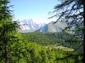
Vista dal Vallone d'Arpy - Comune di Morgex


_-_Panorama.jpg)
_-_Scorcio.jpg)
.jpg)

_-_Scorcio.jpg)


.jpg)
.jpg)
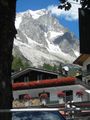
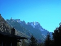
Il Monte Chetif

Monte Chetif e Colle Checroit


Il Monte Chetif ed il Monte Bianco

Il monte Chetif con sullo sfondo la catena del monte Bianco


Tramonto

Tramonto


Versante est

Versante est


Versante nord

Versante nord

Sperone roccioso
_-_Monte_Chetif_-_Vista_panoramica.jpg)


.jpg)
.jpg)
.jpg)
.jpg)
_-_Monte_Chetif_(2).jpg)
.jpg)
.jpg)
.jpg)
_-_Tramonto.jpg)
_-_Tramonto.jpg)
.jpg)
_-_Versante_est.jpg)
_-_Versante_est_(1).jpg)
.jpg)
.jpg)
.jpg)
.jpg)

Il Monte de La Saxe


Il Monte de La Saxe (q.2.340) con sullo sfondo Les Grandes Jorasses (q.4.203)

Il Monte de La Saxe (q.2.340) con sullo sfondo la vetta de Les Grandes Jorasses (q.4.203)

Versante nord orientale di q.1.977

Parete rocciosa versante orientale di q.1.977

Propaggini occidentali
.jpg)
.jpg)
.jpg)
.jpg)


.jpg)


Il Mont Frety (q.2.174)

Il Monte Frety ed il Grandes Jorasses


Il Mont Frety con sullo sfondo il Monte Bianco
Mont Frety - Il Pavillon


(in primo piano)

_-_Grandes_Jorasses_(_sullo_sfondo_).jpg)


.jpg)
.jpg)
.jpg)
.jpg)
.jpg)
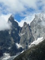
Il Dente del Gigante
- Pur trovandosi in territorio Francese è parte integrante ed inscindibile dello scenario della Catena del Monte Bianco :


Dente del Gigante e Grandes Jorasses


Aiguille de Tules e Dente del Gigante


.jpg)

.jpg)
.jpg)
.jpg)
.jpg)
.jpg)
.jpg)


.jpg)
Aiguille Noire de Peuterey
Aiguille Noire de Peuterey

Aiguille Noire de Peuterey ed il Monte Bianco

Monte Aiguille Noire du Peuterey

Aiguille Noire de Peuterey ed il Monte Bianco

Aiguille Noire de Peuterey ed il Monte Bianco
Aiguille Noire de Peuterey

Aiguille Noire de Peuterey

Aiguille Noire de Peuterey

Aiguille Noire de Peuterey

Val Veny - Costone meridionale Aiguille Noire du Peuterey

Val Veny - Aiguille Noire du Peuterey (q. 3.420)

Val Veny - Mont Rouge de Peuterey e Mont Noir de Peuterey

Val Veny - Aiguille Noire du Peuterey (q. 3.420) (1)

Val Veny - Aiguille Noire du Peuterey (q. 3.420) e Mont Noir de Peuterey

Val Veny - Aiguille Noire du Peuterey (q. 3.420)

Val Veny - Aiguille Noire du Peuterey (q. 3.420)


.jpg)
.jpg)

.jpg)
.jpg)
.jpg)

.jpg)

_(1).jpg)
_e_Mont_Noir_de_Peuterey.jpg)
_(2).jpg)
_(3).jpg)
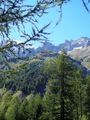
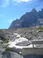
Altre quote

Plan Checroit

Punta Walker q.4.208

Monte Aiguille de l'Eveque q. 3.300

Monte Testa Bernarda q.2.500

Torre de Jetoula q. 3.342

Punte des Conscrits q.3.226(a sinistra) e Trè la Tète q.3.892(a destra)

Punte des Conscrits q.3.226(a sinistra) e Trè la Tète q.3.892(a destra)

Testa d'Arp (q.2.747) e Plan Checrout (q.1.900)

Aiguilles Rouges de Rochefort (q.3.106)

Aiguille della Brenva (q.3.093)

Testa d'Arp (q.2.747)

Val Veny - Aiguille Croux (q. 3.257)

Val Veny - Aiguille Croux (q. 3.257)

Val Veny - Aiguille Croux (q. 3.257) e Mont Rouge de Peuterey

Punta Helbronner (q.3.450)


_e_Tr%C3%A8_la_T%C3%A8te_q.3.892(a_destra).jpg)
_e_Tr%C3%A8_la_T%C3%A8te_q.3.892(a_destra)_(1).jpg)
_e_Plan_Checrout_(q.1.900).jpg)
.jpg)
.jpg)
.jpg)
.jpg)
_(1).jpg)
_e_Mont_Rouge_de_Peuterey.jpg)
.jpg)


