GUIDA Courmayeur/Entreves
Da Wiki.
| (14 revisioni intermedie di 2 utenti non mostrate) | |||
| Riga 1: | Riga 1: | ||
| − | ==Frazione Entreves== | + | ==Courmayeur/Frazione Entreves== |
| + | [[File:Courmayeur - Frazione Entreves - Manifesto.jpg|thumb|left|]] | ||
[[File:Courmayeur - Frazione Entreves - Carta toponomastica Frazione Entreves (in basso) e La Palud (in alto).jpg|thumb|right|Carta toponomastica di Entreves (in basso)]] | [[File:Courmayeur - Frazione Entreves - Carta toponomastica Frazione Entreves (in basso) e La Palud (in alto).jpg|thumb|right|Carta toponomastica di Entreves (in basso)]] | ||
| − | + | [[File:Courmayeur - Frazione Entreves - Ritratto della città.jpg|thumb|right|]] | |
| − | + | ||
| − | + | ||
| − | + | ||
| − | + | ||
| − | + | ||
| − | + | ||
| − | + | ||
| − | + | ||
| − | + | ||
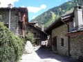
| + | *Ubicata a q. 1.300 metri e posta a nord ovest dal '''Capoluogo, in prossimità dell'imbocco del [[Courmayeur/Traforo del Monte Bianco]] che collega l'[[Italia]] alla Francia, trae il nome dall'espressione "in mezzo alle acque"in quanto sorge tra due fiumi, la '''Dora di Veny''' e la '''Dora di Ferret'''. E' venerata la patrona '''Santa Margherita di Antiochia'''(nacque ad Antiochia di Pisidia nell'anno 275 ed ivi morì nell'anno 290), una fanciulla cristiana che, secondo la tradizione agiografica, subì il martirio sotto '''Massimiano'''. | ||
| + | [[File:Courmayeur - Frazione Entreves - Santa Margherita di Antiochia - Statua lignea.jpg|thumb|right|Santa Margherita di Antiochia]] | ||
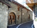
| + | *Due gli edifici storici di maggior interesse: la [[Courmayeur/Casaforte Passerin d'Entreves]] del nobile casato dei '''Passerin''' , edificio di tre piani in pietra a vista, costruito intorno alla metà del Trecento e la [[Courmayeur/Edifici Religiosi/Cappella di Santa Margherita]], databile intorno al XVI secolo. Il turismo muove l'economia locale, grazie anche a strutture dal fascino storico come l''''Auberge de la Maison''', costruito in pietra e in legno su modello delle baite di montagna. Caratteristici della zona ristoranti e taverne ricavati in '''ex case contadine''', dove un tempo si produceva il formaggio. | ||
| + | *La posizione strategica, nel punto di confluenza della [[Courmayeur/Val Veny]] e [[Courmayeur/Val Ferret]], ne fa un punto di appoggio ideale per raggiungere alcuni tra i più spettacolari rifugi del '''Monte Bianco'''. Per mezzo della [[Courmayeur/Impianti a Fune/Funivia "SKYWAY" del Monte Bianco]] si raggiunge il [[Courmayeur/Rifugio Torino Nuovo e Vecchio]] (q. 3.322), presso il '''Colle del Gigante''', punto panoramico alpino tra i più suggestivi della [[Valle d'Aosta]]. | ||
===Panorami=== | ===Panorami=== | ||
| Riga 22: | Riga 18: | ||
Immagine:Courmayeur - Frazione Entreves - Panorama (4).jpg| | Immagine:Courmayeur - Frazione Entreves - Panorama (4).jpg| | ||
Immagine:Courmayeur - Frazione Entreves - Panorama (5).jpg| | Immagine:Courmayeur - Frazione Entreves - Panorama (5).jpg| | ||
| + | File:Courmayeur - Frazione Entreves - Panorama (6).jpg| | ||
| + | File:Courmayeur - Frazione Entreves - Panorama (7).jpg| | ||
</gallery> | </gallery> | ||
| Riga 32: | Riga 30: | ||
Immagine:Courmayeur - Frazione Entreves - Scorcio (5).jpg| | Immagine:Courmayeur - Frazione Entreves - Scorcio (5).jpg| | ||
File:Courmayeur - Frazione Entreves - Scorcio (6).jpg| | File:Courmayeur - Frazione Entreves - Scorcio (6).jpg| | ||
| + | File:Courmayeur - Frazione Entreves - Scorcio (7).jpg| | ||
| + | File:Courmayeur - Frazione Entreves - Scorcio (8).jpg| | ||
| + | File:Courmayeur - Frazione Entreves - Scorcio (9).jpg| | ||
| + | File:Courmayeur - Frazione Entreves - Scorcio (10).jpg| | ||
| + | File:Courmayeur - Frazione Entreves - Scorcio (11).jpg| | ||
| + | File:Courmayeur - Frazione Entreves - Scorcio (12).jpg| | ||
| + | File:Courmayeur - Frazione Entreves - Scorcio (13).jpg| | ||
| + | File:Courmayeur - Frazione Entreves - Scorcio (14).jpg| | ||
| + | File:Courmayeur - Frazione Entreves - Scorcio (15).jpg| | ||
| + | File:Courmayeur - Frazione Entreves - Scorcio (16).jpg| | ||
| + | File:Courmayeur - Frazione Entreves - Scorcio (17).jpg| | ||
</gallery> | </gallery> | ||
| Riga 38: | Riga 47: | ||
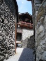
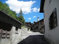
===Vie e Piazze=== | ===Vie e Piazze=== | ||
<gallery> | <gallery> | ||
| − | Immagine:Courmayeur - Frazione Entreves - Vicolo.jpg| | + | Immagine:Courmayeur - Frazione Entreves - Vicolo.jpg| |
Immagine:Courmayeur - Frazione Entreves - Via Passerin d'Entreves.jpg|Via Passerin d'Entreves | Immagine:Courmayeur - Frazione Entreves - Via Passerin d'Entreves.jpg|Via Passerin d'Entreves | ||
Immagine:Courmayeur - Frazione Entreves - Via Colle del Gigante.jpg|Via Colle del Gigante | Immagine:Courmayeur - Frazione Entreves - Via Colle del Gigante.jpg|Via Colle del Gigante | ||
| Riga 45: | Riga 54: | ||
Immagine:Courmayeur - Frazione Entreves - Via Grandes Jorasses.jpg|Via Grandes Jorasses | Immagine:Courmayeur - Frazione Entreves - Via Grandes Jorasses.jpg|Via Grandes Jorasses | ||
Immagine:Courmayeur - Frazione Entreves - Via Grandes Jorasses (1).jpg|Via Grandes Jorasses | Immagine:Courmayeur - Frazione Entreves - Via Grandes Jorasses (1).jpg|Via Grandes Jorasses | ||
| + | Immagine:Courmayeur - Frazione Entreves - Vicolo (1).jpg| | ||
| + | Immagine:Courmayeur - Frazione Entreves - Vicolo e piazzetta.jpg| | ||
| + | Immagine:Courmayeur - Frazione Entreves - Vicolo (2).jpg| | ||
| + | Immagine:Courmayeur - Frazione Entreves - Vicolo (3).jpg| | ||
| + | File:Courmayeur - Frazione Entreves - Rotatoria sulla Strada Statale 26.jpg|Rotatoria sulla Strada Statale 26 | ||
| + | |||
</gallery> | </gallery> | ||
| Riga 53: | Riga 68: | ||
Immagine:Courmayeur - Frazione Entreves - Area attrezzata per pic-nic (2).jpg| | Immagine:Courmayeur - Frazione Entreves - Area attrezzata per pic-nic (2).jpg| | ||
Immagine:Courmayeur - Frazione Entreves - Courmayeur - Frazione Entreves - Area attrezzata per pic-nic (3).jpg| | Immagine:Courmayeur - Frazione Entreves - Courmayeur - Frazione Entreves - Area attrezzata per pic-nic (3).jpg| | ||
| + | File:Courmayeur - Frazione Entreves - Area attrezzata per pic-nic (4) - Panoramica.jpg| | ||
</gallery> | </gallery> | ||
| Riga 61: | Riga 77: | ||
Immagine:Courmayeur - Frazione Entreves - Fontanella - Fiorera.jpg|Fontanella - Fiorera | Immagine:Courmayeur - Frazione Entreves - Fontanella - Fiorera.jpg|Fontanella - Fiorera | ||
Immagine:Courmayeur - Frazione Entreves - Fontana (3).jpg|Fontana | Immagine:Courmayeur - Frazione Entreves - Fontana (3).jpg|Fontana | ||
| + | File:Courmayeur - Frazione Entreves - Fontana (4).jpg|Fontana | ||
</gallery> | </gallery> | ||
===Varie=== | ===Varie=== | ||
<gallery> | <gallery> | ||
| − | Immagine:Courmayeur - Lunario - Frazione Entreves.jpg|Lunario | + | Immagine:Courmayeur - Lunario - Frazione Entreves.jpg|Lunario |
| − | Immagine:Courmayeur - Viadotto autostrada A5 ( carreggiata sud ) - Frazione Entreves.jpg|Viadotto autostrada A5 (carreggiata sud) | + | Immagine:Courmayeur - Viadotto autostrada A5 ( carreggiata sud ) - Frazione Entreves.jpg|Viadotto autostrada A5 ( carreggiata sud ) |
| − | + | File:Courmayeur - Frazione Entreves - Viadotto autostrada A5 (carreggiata nord - tratto).jpg|Viadotto autostrada A5 (carreggiata nord - tratto) | |
| − | + | ||
| − | + | ||
| − | + | ||
| − | + | ||
| − | + | ||
| − | + | ||
| − | File:Courmayeur - Frazione Entreves - | + | |
| − | + | ||
| − | + | ||
</gallery> | </gallery> | ||
[[Categoria:Località]] | [[Categoria:Località]] | ||
Versione attuale delle 10:05, 26 lug 2019
Indice |
Courmayeur/Frazione Entreves

_e_La_Palud_(in_alto).jpg)

- Ubicata a q. 1.300 metri e posta a nord ovest dal Capoluogo, in prossimità dell'imbocco del Traforo del Monte Bianco che collega l'Italia alla Francia, trae il nome dall'espressione "in mezzo alle acque"in quanto sorge tra due fiumi, la Dora di Veny e la Dora di Ferret. E' venerata la patrona Santa Margherita di Antiochia(nacque ad Antiochia di Pisidia nell'anno 275 ed ivi morì nell'anno 290), una fanciulla cristiana che, secondo la tradizione agiografica, subì il martirio sotto Massimiano.

- Due gli edifici storici di maggior interesse: la Casaforte Passerin d'Entreves del nobile casato dei Passerin , edificio di tre piani in pietra a vista, costruito intorno alla metà del Trecento e la Cappella di Santa Margherita, databile intorno al XVI secolo. Il turismo muove l'economia locale, grazie anche a strutture dal fascino storico come l'Auberge de la Maison, costruito in pietra e in legno su modello delle baite di montagna. Caratteristici della zona ristoranti e taverne ricavati in ex case contadine, dove un tempo si produceva il formaggio.
- La posizione strategica, nel punto di confluenza della Val Veny e Val Ferret, ne fa un punto di appoggio ideale per raggiungere alcuni tra i più spettacolari rifugi del Monte Bianco. Per mezzo della Funivia "SKYWAY" del Monte Bianco si raggiunge il Rifugio Torino Nuovo e Vecchio (q. 3.322), presso il Colle del Gigante, punto panoramico alpino tra i più suggestivi della Valle d'Aosta.
Panorami


Frazione Entreves e Piazzale accesso Traforo Monte Bianco


.jpg)
.jpg)
.jpg)
.jpg)
.jpg)
.jpg)
Scorci
.jpg)
.jpg)
.jpg)
.jpg)
.jpg)
.jpg)
.jpg)
.jpg)
.jpg)
.jpg)
.jpg)
.jpg)
.jpg)
Edifici Cittadini
Vie e Piazze
Via Passerin d'Entreves

Via Colle del Gigante

Strada della Brenva

Strada della Brenva
Via Grandes Jorasses
Via Grandes Jorasses


Rotatoria sulla Strada Statale 26


.jpg)

.jpg)
.jpg)

.jpg)
.jpg)

Area attrezzata per pic-nic

.jpg)
.jpg)
.jpg)
_-_Panoramica.jpg)
Fontane

Fontana

Lavatoio coperto

Fontanella - Fiorera

Fontana

Fontana
.jpg)


.jpg)
.jpg)
Varie

Lunario

Viadotto autostrada A5 ( carreggiata sud )

Viadotto autostrada A5 (carreggiata nord - tratto)

.jpg)


