GUIDA Courmayeur/Val Ferret
(→Planpincieux) |
|||
| (130 revisioni intermedie di 3 utenti non mostrate) | |||
| Riga 1: | Riga 1: | ||
==Val Ferret== | ==Val Ferret== | ||
| − | + | [[File:Courmayeur - Caratteristiche del Territorio - Carta dei sentieri - Val Ferret e Val Sapin.jpg|thumb|left|Carta dei sentieri - Val Ferret e Val Sapin]] | |
| + | [[File:Courmayeur - Media Val Ferret - Carta turististica.jpg|thumb|right|Media Val Ferret - Carta turististica]] | ||
| + | *Di origine glaciale (con sezione ad U svasata verso l'alto)ed andamento sud-ovest / nord-est,con accesso dalla Frazione di [[../La Palud]],la valle è caratterizzata da un primo tratto boschivo con ampi spazi prativi(circa 6 km ) ed un secondo tratto completamente privo di vegetazione arborea(cira 6 km).Percorsa dal ramo della '''Dora di Ferret''' ( con origine dai ghiacciai del massiccio de '''Les Grandes Jorasses''' e della catena '''Aig.de Talefrè''' - '''Aig.de Triolet''' ) frontalmente,a sud-ovest,ha inizio la [[../Val Veny]], con accesso dalla Frazione [[../La Saxe]].La destra orografica della valle è rappresentata dalla catena alpina precedentemente menzionata e presenta diversi ghiacciai permanenti fra i quali,i più estesi,sono (partendo da nord est in direzione sud ovest): [[Courmayeur/Caratteristiche del Territorio/Glacier de Prè de Bar]] ,[[Courmayeur/Caratteristiche del Territorio/Glacier de Triolet]] , [[Courmayeur/Caratteristiche del Territorio/Glacier de Frebouze]] , [[Courmayeur/Caratteristiche del Territorio/Glacier de Planpincieux]] , [[Courmayeur/Caratteristiche del Territorio/Glacier de Rochefort]] .I ghiacciai di minore estensione sono(partendo da nord est in direzione sud ovest): [[Courmayeur/Caratteristiche del Territorio/Glacier de Gruetta]] , [[Courmayeur/Caratteristiche del Territorio/Glacier des Grandes Jorasses]] , [[Courmayeur/Caratteristiche del Territorio/Glacier de Pra Sec]] , [[Courmayeur/Caratteristiche del Territorio/Glacier de Tronchey]] , [[Courmayeur/Caratteristiche del Territorio/Glacier de Col du Geant]] , [[Courmayeur/Caratteristiche del Territorio/Glacier du Mont Frety]] . | ||
| + | *La testata della Valle è costituita dalla '''Tete de Ferret''' (q.2.714).Alla sinistra idrografica del Fiume '''Dora di Ferret''' fanno corona il '''Gr. Goliat''' (q.3.237), '''Monte Chichet''' (q.3.043), '''Aig.de Chambave''' (q.3.067) e la dorsale del '''Monte de La Saxe''' ( q.2.348). | ||
| + | *Interdetta d'inverno al transito automobilistico,d'estate lo stesso è regolamentato. | ||
| − | === | + | ===Bivacchi=== |
| + | *'''Canzio''': Sito sul "Colle delle Grandes Jorasses",a quota 3.818 metri,dispone di 8 posti letto ed :è raggiungibile dal [[../Rifugio Gabriele Boccalatte e Mario Piolti]]. | ||
| + | *'''Fiorio-Dolent''': Sito a "Pré de Bar",a quota 2.800 metri,dispone di 30 posti letto ed è :raggiungibile dalla località "Arnouvaz" . | ||
| + | *'''Gervasutti Giusto''': Sito sul "Ghiacciaio del Fréboudze",a quota 2.870 metri,dispone di 8 posti letto ed :è raggiungibile dalla località "Fréboudze" . | ||
| + | *'''Gianni Comino''' : Sito sul "Monte Greuvetta",a quota 2.430 metri,dispone di 9 posti letto ed è :raggiungibile dalla località "Arnouvaz". | ||
| + | *'''Jacchia''' : Sito su "L’Aiguille de l’Évêque",a quota 3.264 metri,dispone di 6 posti letto ed è :raggiungibile dalla località "Tronchey". | ||
| + | *'''Fréboudze''':sito alle pendici del Monte "Rouge di Gruetta" a quota 2.363 metri,dispone di 4 posti letto ed è raggiungibile dalla località "Vachey" seguendo il torrente "Fréboudze". | ||
| + | |||
| + | ===Modulo tipo per Bivacco=== | ||
<gallery> | <gallery> | ||
| − | Immagine:Courmayeur - | + | Immagine:Courmayeur - Modulo tipo per bivacco - Vista d'insieme.jpg|Vista d'insieme |
| − | Immagine:Courmayeur - | + | Immagine:Courmayeur - Modulo tipo per bivacco - Fronte.jpg|Fronte |
| + | Immagine:Courmayeur - Modulo tipo per bivacco - Interno lato destro.jpg|Interno lato destro | ||
| + | Immagine:Courmayeur - Modulo tipo per bivacco - Interno lato sinistro.jpg|Interno lato sinistro | ||
| + | </gallery> | ||
| + | |||
| + | ==Immagini== | ||
| + | ===Panorami=== | ||
| + | <gallery> | ||
| + | Immagine:Courmayeur - Val Ferret - Accesso alla vallata.jpg|Accesso alla vallata | ||
| + | Immagine:Courmayeur - Località La Palud e la Val Ferret - Vista d'insieme.jpg|Frazione La Palud | ||
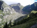
Immagine:Courmayeur - Dente del Gigante e Grandes Jorasses - Panorama.jpg|Dente del Gigante e Grandes Jorasses | Immagine:Courmayeur - Dente del Gigante e Grandes Jorasses - Panorama.jpg|Dente del Gigante e Grandes Jorasses | ||
| + | Immagine:Courmayeur - Les Grandes Jorasses ed il Monte della Saxe.jpg|Les Grandes Jorasses ed il Monte della Saxe | ||
Immagine:Courmayeur - Val Ferret - Panorama dal Monte Chetif q.2343.jpg|La valle vista dal Monte Chetif | Immagine:Courmayeur - Val Ferret - Panorama dal Monte Chetif q.2343.jpg|La valle vista dal Monte Chetif | ||
| + | Immagine:Courmayeur - Val Ferret - Parte iniziale vallata.jpg|Val Ferret - Parte iniziale vallata | ||
| + | Immagine:Courmayeur - Val Ferret - Media e bassa valle.jpg|Val Ferret - Media e bassa valle | ||
| + | Immagine:Courmayeur - Val Ferret - Monte Gran Col Ferret q.2.537.jpg|Monte Gran Col Ferret q.2.537 | ||
| + | Immagine:Courmayeur - Val Ferret - Les Grandes Jorasses (2).jpg|Les Grandes Jorasses | ||
| + | Immagine:Courmayeur - Val Ferret - Cima delle Grandes Jorasses.jpg|Cima delle Grandes Jorasses | ||
| + | Immagine:Courmayeur - Val Ferret - Dente del Gigante (2).jpg|Dente del Gigante | ||
| + | Immagine:Courmayeur - Val Ferret - Media ed alta valle.jpg|Media ed alta valle | ||
| + | Immagine:Courmayeur - Val Ferret - Bassa Valle.jpg|Bassa Valle | ||
| + | Immagine:Courmayeur - Val Ferret - Media valle (3).jpg|Media valle | ||
| + | Immagine:Courmayeur - Val Ferret - Vallone del Malatrà.jpg|Vallone del Malatrà | ||
| + | Immagine:Courmayeur - Val Ferret - Dora di Ferret (tratto) (2).jpg|Dora di Ferret (tratto) | ||
| + | File:Courmayeur - Val Ferret - Massiccio delle Grandes Jorasses (sullo sfondo) e Mont Frety (primo piano).jpg|Massiccio delle Grandes Jorasses (sullo sfondo) e Mont Frety (primo piano) | ||
| + | File:Courmayeur - Bassa e Media Val Ferret - Dal Dente del Gigante alle Grandes Jorasses.jpg|Dal Dente del Gigante alle Grandes Jorasses | ||
| + | File:Courmayeur - Caratteristiche del Territorio - Bassa e media Val Ferret.jpg|Bassa e media Val Ferret | ||
| + | File:Courmayeur - Caratteristiche del Territorio - Bassa Val Ferret.jpg|Bassa Val Ferret | ||
| + | File:Courmayeur - Val Ferret - scorcio.jpg|Alta Val Ferret | ||
| + | File:Courmayeur - Scorcio - Val Ferret.jpg|Alta Val Ferret | ||
| + | File:Courmayeur - Alta Val Ferret.jpg|Alta Val Ferret | ||
</gallery> | </gallery> | ||
| + | ===Scorci=== | ||
| + | <gallery> | ||
| + | Immagine:Courmayeur - Val Ferret - Scorcio media valle.jpg|Scorcio media valle | ||
| + | Immagine:Courmayeur - Val Ferret - Rio di Belle Combe - Cascate.jpg|Rio di Belle Combe - Cascate | ||
| + | Immagine:Courmayeur - Val Ferret - Origine della vallata e della Dora di Ferret.jpg|Origine della vallata e della Dora di Ferret | ||
| + | Immagine:Courmayeur - Val Ferret - Media valle.jpg|Val Ferret - Media valle | ||
| + | Immagine:Courmayeur - Val Ferret - Piccolo Col Ferret q.2.490.jpg|Val Ferret - Piccolo Col Ferret q.2.490 | ||
| + | Immagine:Courmayeur - Val Ferret - Piccolo Col Ferret q.2.490 (2).jpg|Piccolo Col Ferret q.2.490 | ||
| + | Immagine:Courmayeur - Val Ferret - Vetta del Monte Bianco.jpg|Vetta del Monte Bianco | ||
| + | Immagine:Courmayeur - Val Ferret - Rio di Belle Combe.jpg|Rio di Belle Combe | ||
| + | Immagine:Courmayeur - Val Ferret - Monti Gruetta.jpg|Monti Gruetta | ||
| + | Immagine:Courmayeur - Val Ferret - Monte de la Saxe.jpg|Monte de la Saxe | ||
| + | Immagine:Courmayeur - Val Ferret - Dora di Ferret (tratto).jpg|Dora di Ferret (tratto) | ||
| + | Immagine:Courmayeur - Val Ferret - Monte de la Saxe (2).jpg|Monte de la Saxe | ||
| + | Immagine:Courmayeur - Val Ferret - Media valle (2).jpg|Media valle | ||
| + | Immagine:Courmayeur - Val Ferret - Monte Tete entre deux Sauts q. 2.729.jpg|Monte Tete entre deux Sauts q. 2.729 | ||
| + | File:Courmayeur - Ponte in legno.jpg | ||
| + | File:Courmayeur - Ponte in legno 2.jpg | ||
| + | File:Courmayeur - Ponte in legno 3.jpg | ||
| + | File:Courmayeur - Ponte in legno 4.jpg | ||
| + | </gallery> | ||
| + | |||
| + | ==Località== | ||
| + | |||
| + | ==='''Arnouva'''=== | ||
| + | <gallery> | ||
| + | Immagine:Courmayeur - Val Ferret - Piana dell'Arnuva.jpg|Piana dell'Arnouva | ||
| + | Immagine:Courmayeur - Val Ferret - Piana dell'Arnuva (2).jpg|Piana dell'Arnouva | ||
| + | Immagine:Courmayeur - Val Ferret - Piana dell'Arnuva (3).jpg|Piana dell'Arnouva | ||
| + | Immagine:Courmayeur - Val Ferret - Località Arnuva - Chalet Val Ferret.jpg|Chalet Val Ferret | ||
| + | Immagine:Courmayeur - Val Ferret - Ponte sul rio "des Econduits".jpg|Ponte sul rio "des Econduits" | ||
| + | Immagine:Courmayeur - Val Ferret - Chalet Val Ferret (2).jpg|Chalet Val Ferret | ||
| + | Immagine:Courmayeur - Val Ferret - Chalet Val Ferret (3).jpg|Chalet Val Ferret | ||
| + | Immagine:Courmayeur - Val Ferret - Chalet Val Ferret - Sala ristorante.jpg|Chalet Val Ferret - Sala ristorante | ||
| + | </gallery> | ||
| + | |||
| + | ==='''Meyenchet'''=== | ||
| + | <gallery> | ||
| + | Immagine:Courmayeur - Val Ferret - Località Meyenchet q. 1.616 - Tratto fiume Dora.jpg|Tratto fiume Dora | ||
| + | Immagine:Courmayeur - Val Ferret - Località Meyenchet q. 1.616 - Baite.jpg|Baite | ||
| + | Immagine:Courmayeur - Val Ferret - Località Meyenchet q. 1.616.jpg|Scorcio | ||
| + | Immagine:Courmayeur - Val Ferret - Località Meyenchet - Scorcio.jpg|Scorcio | ||
| + | Immagine:Courmayeur - Val Ferret - Località Meyenchet - Ponti.jpg|Ponti | ||
| + | Immagine:Courmayeur - Val Ferret - Località Meyenchet - Dora di Ferret - Tratto.jpg|Dora di Ferret - Tratto | ||
| + | Immagine:Courmayeur - Val Ferret - Località Meyenchet - Scorcio (6).jpg|Scorcio | ||
| + | Immagine:Courmayeur - Val Ferret - Località Meyenchet - Scorcio (5).jpg|Scorcio | ||
| + | Immagine:Courmayeur - Val Ferret - Località Meyenchet q. 1.616 - Baite d'alpeggio.jpg|Baite d'alpeggio | ||
| + | </gallery> | ||
| + | |||
| + | ==='''Tronchey'''=== | ||
| + | <gallery> | ||
| + | Immagine:Courmayeur - Val Ferret - Località Tronchey q. 1.620 (2).jpg|Località Tronchey q. 1.620 | ||
| + | Immagine:Courmayeur - Val Ferret - Località Tronchey q. 1.620.jpg|Località Tronchey q. 1.620 | ||
| + | Immagine:Courmayeur - Val Ferret - Località Tronchey - Scorcio (2).jpg|Località Tronchey q. 1.620 | ||
| + | Immagine:Courmayeur - Località Tronchey - Scorcio (3).jpg|Località Tronchey q. 1.620 | ||
| + | </gallery> | ||
| + | |||
| + | ==='''Le Pont'''=== | ||
| + | <gallery> | ||
| + | Immagine:Courmayeur - Val Ferret - Località Le Pont.jpg|Panorama | ||
| + | Immagine:Courmayeur - Val Ferret - Località Le Pont - Scorcio (7).jpg|Scorcio | ||
| + | Immagine:Courmayeur - Val Ferret - Cappella (3).jpg|Cappella | ||
| + | Immagine:Courmayeur - Val Ferret - Località Le Pont - Cappella.jpg|Cappella | ||
| + | Immagine:Courmayeur - Val Ferret - Località Le Pont - Cappella (vista laterale).jpg|Cappella (vista laterale) | ||
| + | Immagine:Courmayeur - Val Ferret - Località Le Pont - Ristorante.jpg|Ristorante | ||
| + | Immagine:Courmayeur - Val Ferret - Località Le Pont - Scorcio (8).jpg|Scorcio | ||
| + | Immagine:Courmayeur - Val Ferret - Località Le Pont - Scorcio (9).jpg|Scorcio | ||
| + | Immagine:Courmayeur - Val Ferret - Località Le Pont - Fontana.jpg|Fontana | ||
| + | </gallery> | ||
| + | |||
| + | ==='''Planpincieux'''=== | ||
| + | |||
| + | {{#widget:YouTube|id=NgbFNuODQAM}} | ||
| + | |||
| + | <gallery> | ||
| + | Immagine:Courmayeur - Val Ferret - Località Planpincieux.jpg|Località Planpincieux | ||
| + | Immagine:Courmayeur - Località Planpincieux - Scorcio (5).jpg|Scorcio | ||
| + | Immagine:Courmayeur - Val Ferret - Località Planpincieux - Cappella.jpg|Cappella | ||
| + | Immagine:Courmayeur - Cappella - Vista frontale.jpg|Cappella | ||
| + | Immagine:Courmayeur - Località Planpincieux - Cappella (vista posteriore).jpg|Cappella (vista posteriore) | ||
| + | Immagine:Courmayeur - Località Planpincieux - Cappella (interno).jpg|Cappella (interno) | ||
| + | Immagine:Courmayeur - Località Planpincieux - Cappella (coro).jpg|Cappella (coro) | ||
| + | Immagine:Courmayeur - Località Planpincieux - Pilone votivo.jpg|Pilone votivo | ||
| + | Immagine:Courmayeur - Località Planpincieux - Centro del fondo.jpg|Centro del fondo | ||
| + | Immagine:Courmayeur - Località Planpincieux - Meridiana.jpg|Meridiana | ||
| + | Immagine:Courmayeur - Località Planpincieux - Residence.jpg|Residence | ||
| + | Immagine:Courmayeur - Località Planpincieux - Villetta.jpg|Villetta | ||
| + | Immagine:Courmayeur - Località Planpincieux - Scorcio.jpg|Scorcio | ||
| + | Immagine:Courmayeur - Località Planpincieux - Area giochi e solarium.jpg|Area giochi e solarium | ||
| + | Immagine:Courmayeur - Val Ferret - Località Planpincieux - Baita a Montite.jpg|Baita a Montite | ||
| + | Immagine:Courmayeur - Val Ferret - Località Planpincieux - Baita a Montite (2).jpg|Baita a Montite | ||
| + | Immagine:Courmayeur - Val Ferret - Località Planpincieux - Baita a Montite (3).jpg|Baita a Montite | ||
| + | File:Courmayeur - Val Ferret - dettaglio chiesa.jpg|Dettaglio cappella | ||
| + | </gallery> | ||
| + | |||
| + | ==='''Meyen'''=== | ||
| + | <gallery> | ||
| + | Immagine:Courmayeur - Val Ferret - Località Meyen.jpg|Località Meyen | ||
| + | Immagine:Courmayeur - Val Ferret - Località Meyen - Ponti sul torrente Meyen.jpg|Ponti sul torrente Meyen | ||
| + | </gallery> | ||
| + | |||
| + | ==='''Lavachey'''=== | ||
| + | <gallery> | ||
| + | Immagine:Courmayeur - Val Ferret - Località Lavachey - Scorcio (7).jpg|Scorcio | ||
| + | Immagine:Courmayeur - Val Ferret - Località Prà Sec q. 1630.jpg|Ristoranti | ||
| + | Immagine:Courmayeur - Val Ferret - Località La Vachey - Laghetto pesca della trota.jpg|Laghetto pesca della trota | ||
| + | Immagine:Courmayeur - Val Ferret - Località Lavachey - Laghetto pesca della trota (2).jpg|Laghetto pesca della trota | ||
| + | Immagine:Courmayeur - Val Ferret - Località Lavachey - Fiume Dora di Ferret (tratto).jpg|Fiume Dora di Ferret (tratto) | ||
| + | Immagine:Courmayeur - Val Ferret - Località Lavachey - Fiume Dora di Ferret (tratto) (2).jpg|Fiume Dora di Ferret (tratto).jpg|Fiume Dora di Ferret (tratto) | ||
| + | Immagine:Courmayeur - Val Ferret - Località Lavachey - Dora di Ferret (tratto) (3).jpg|Fiume Dora di Ferret (tratto) | ||
| + | Immagine:Courmayeur - Val Ferret - Località Lavachey - Scorcio (8).jpg|Scorcio | ||
| + | Immagine:Courmayeur - Val Ferret - Località Lavachey - Chalet Mont Dolent.jpg|Chalet Mont Dolent | ||
| + | Immagine:Courmayeur - Val Ferret - Località Lavachey - Hotel.jpg|Hotel | ||
| + | Immagine:Courmayeur - Val Ferret - Località Lavachey - Baite di Frebouze.jpg|Baite di Frebouze | ||
| + | Immagine:Courmayeur - Scorcio val Ferret.jpg|Scorcio dal Rifugio Elena | ||
| + | Immagine:Courmayeur - Scorcio val Ferret - 2.jpg|Scorcio dal Rifugio Elena | ||
| + | </gallery> | ||
| + | |||
| + | ==='''Prà Sec'''=== | ||
| + | <gallery> | ||
| + | Immagine:Courmayeur - Val Ferret - Rio Prà Sec.jpg|Rio Prà Sec | ||
| + | Immagine:Courmayeur - Val Ferret - Località Prà Sec - Ristorante.jpg|Ristorante | ||
| + | Immagine:Courmayeur - Val Ferret - Località Prà Sec - Ristorante La Grantze.jpg|Ristorante La Grantze | ||
| + | Immagine:Courmayeur - Val Ferret - Località Prà Sec - Fiume Dora di Ferret (tratto) (3).jpg|Fiume Dora di Ferret (tratto) | ||
| + | Immagine:Courmayeur - Val Ferret - Località Prà Sec - Fiume Dora di Ferret (tratto) (4).jpg|Fiume Dora di Ferret (tratto) | ||
| + | Immagine:Courmayeur - Val Ferret - Località Prà Sec - Dora di Ferret (tratto) (4).jpg|Fiume Dora di Ferret (tratto) | ||
| + | </gallery> | ||
| + | |||
| + | ==='''Pra Neyron'''=== | ||
| + | <gallery> | ||
| + | Immagine:Courmayeur - Val Ferret - Località Pra Neyron - Dora di Ferret (tratto).jpg|Dora di Ferret (tratto) | ||
| + | Immagine:Courmayeur - Val Ferret - Località Pra Neyron - Ponte sul Torrente Marguera.jpg|Ponte sul Torrente Marguera | ||
| + | </gallery> | ||
| + | |||
| + | ==='''Rochefort'''=== | ||
| + | <gallery> | ||
| + | Immagine:Courmayeur - Val Ferret - Località Rochefort q.1.726.jpg|Località Rochefort q.1.726 | ||
| + | </gallery> | ||
| + | |||
| + | ==Varie== | ||
| + | <gallery> | ||
| + | Immagine:Courmayeur - Val Ferret - "Savoiarde" al pascolo (quota 2000 metri).jpg|"Savoiarde" al pascolo (quota 2000 metri) | ||
| + | Immagine:Courmayeur - Val Ferret - Ponte sul rio "des Econduits".jpg|Ponte sul rio "des Econduits" | ||
| + | Immagine:Courmayeur - Val Ferret - Alpeggio a quota 2.000 metri.jpg|Alpeggio a quota 2.000 metri | ||
| + | Immagine:Courmayeur - Val Ferret - Alpeggio a quota 2.000 metri (2).jpg|Alpeggio a quota 2.000 metri | ||
| + | Immagine:Courmayeur - Val Ferret - I tre somari "guardiani" del pascolo.jpg|I tre somari "guardiani" del pascolo | ||
| + | Immagine:Courmayeur - Val Ferret - Ruscello.jpg|Ruscello | ||
| + | Immagine:Courmayeur - Val Ferret - Trekking.jpg|Trekking | ||
| + | Immagine:Courmayeur - Val Ferret - Trekking (2).jpg|Trekking | ||
| + | Immagine:Courmayeur - Val Ferret - Ponte in legno sulla Dora di Ferret.jpg|Ponte in legno sulla Dora di Ferret | ||
| + | </gallery> | ||
[[Categoria:Gallerie Foto]] | [[Categoria:Gallerie Foto]] | ||
| + | |||
| + | ==Video== | ||
| + | |||
| + | *'''Alta Val Ferret''' {{#widget:YouTube|id=XR6m6zIvh1Y}} | ||
| + | |||
| + | --------------------------------------- | ||
| + | |||
| + | *''' "Elitrasporto" di materiali sul Monte La Saxe (q.2.000)''' {{#widget:YouTube|id=NsMqhedSw68}} | ||
Versione attuale delle 18:00, 2 gen 2021
Indice |
Val Ferret


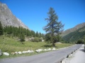
- Di origine glaciale (con sezione ad U svasata verso l'alto)ed andamento sud-ovest / nord-est,con accesso dalla Frazione di La Palud,la valle è caratterizzata da un primo tratto boschivo con ampi spazi prativi(circa 6 km ) ed un secondo tratto completamente privo di vegetazione arborea(cira 6 km).Percorsa dal ramo della Dora di Ferret ( con origine dai ghiacciai del massiccio de Les Grandes Jorasses e della catena Aig.de Talefrè - Aig.de Triolet ) frontalmente,a sud-ovest,ha inizio la Val Veny, con accesso dalla Frazione La Saxe.La destra orografica della valle è rappresentata dalla catena alpina precedentemente menzionata e presenta diversi ghiacciai permanenti fra i quali,i più estesi,sono (partendo da nord est in direzione sud ovest): Glacier de Prè de Bar ,Glacier de Triolet , Glacier de Frebouze , Glacier de Planpincieux , Glacier de Rochefort .I ghiacciai di minore estensione sono(partendo da nord est in direzione sud ovest): Glacier de Gruetta , Glacier des Grandes Jorasses , Glacier de Pra Sec , Glacier de Tronchey , Glacier de Col du Geant , Glacier du Mont Frety .
- La testata della Valle è costituita dalla Tete de Ferret (q.2.714).Alla sinistra idrografica del Fiume Dora di Ferret fanno corona il Gr. Goliat (q.3.237), Monte Chichet (q.3.043), Aig.de Chambave (q.3.067) e la dorsale del Monte de La Saxe ( q.2.348).
- Interdetta d'inverno al transito automobilistico,d'estate lo stesso è regolamentato.
Bivacchi
- Canzio: Sito sul "Colle delle Grandes Jorasses",a quota 3.818 metri,dispone di 8 posti letto ed :è raggiungibile dal Rifugio Gabriele Boccalatte e Mario Piolti.
- Fiorio-Dolent: Sito a "Pré de Bar",a quota 2.800 metri,dispone di 30 posti letto ed è :raggiungibile dalla località "Arnouvaz" .
- Gervasutti Giusto: Sito sul "Ghiacciaio del Fréboudze",a quota 2.870 metri,dispone di 8 posti letto ed :è raggiungibile dalla località "Fréboudze" .
- Gianni Comino : Sito sul "Monte Greuvetta",a quota 2.430 metri,dispone di 9 posti letto ed è :raggiungibile dalla località "Arnouvaz".
- Jacchia : Sito su "L’Aiguille de l’Évêque",a quota 3.264 metri,dispone di 6 posti letto ed è :raggiungibile dalla località "Tronchey".
- Fréboudze:sito alle pendici del Monte "Rouge di Gruetta" a quota 2.363 metri,dispone di 4 posti letto ed è raggiungibile dalla località "Vachey" seguendo il torrente "Fréboudze".
Modulo tipo per Bivacco

Vista d'insieme

Fronte

Interno lato destro

Interno lato sinistro


Immagini
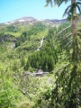
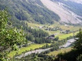
Panorami
Accesso alla vallata

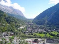
Frazione La Palud

Dente del Gigante e Grandes Jorasses

Les Grandes Jorasses ed il Monte della Saxe
La valle vista dal Monte Chetif

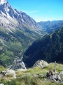
Val Ferret - Parte iniziale vallata

Val Ferret - Media e bassa valle

Monte Gran Col Ferret q.2.537

Les Grandes Jorasses

Cima delle Grandes Jorasses
Dente del Gigante

Media ed alta valle

Bassa Valle

Media valle

Vallone del Malatrà
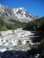
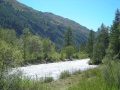
Dora di Ferret (tratto)

Massiccio delle Grandes Jorasses (sullo sfondo) e Mont Frety (primo piano)

Dal Dente del Gigante alle Grandes Jorasses

Bassa e media Val Ferret

Bassa Val Ferret

Alta Val Ferret

Alta Val Ferret

Alta Val Ferret


.jpg)

.jpg)


.jpg)

_(2).jpg)
_e_Mont_Frety_(primo_piano).jpg)


Scorci

Scorcio media valle

Rio di Belle Combe - Cascate
Origine della vallata e della Dora di Ferret

Val Ferret - Media valle

Val Ferret - Piccolo Col Ferret q.2.490

Piccolo Col Ferret q.2.490

Vetta del Monte Bianco

Rio di Belle Combe

Monti Gruetta

Monte de la Saxe

Dora di Ferret (tratto)

Monte de la Saxe

Media valle

Monte Tete entre deux Sauts q. 2.729


.jpg)


.jpg)
.jpg)
.jpg)


Località
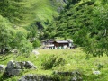
Arnouva

Piana dell'Arnouva

Piana dell'Arnouva

Piana dell'Arnouva

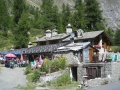
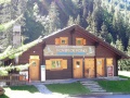
Chalet Val Ferret

Ponte sul rio "des Econduits"
Chalet Val Ferret

Chalet Val Ferret

Chalet Val Ferret - Sala ristorante

.jpg)
.jpg)

.jpg)
.jpg)

Meyenchet

Tratto fiume Dora
Baite

Scorcio

Scorcio

Ponti

Dora di Ferret - Tratto
Scorcio

Scorcio
Baite d'alpeggio


.jpg)
.jpg)

Tronchey
Località Tronchey q. 1.620

Località Tronchey q. 1.620

Località Tronchey q. 1.620

Località Tronchey q. 1.620
.jpg)

.jpg)
.jpg)
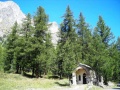
Le Pont

Panorama

Scorcio

Cappella
Cappella
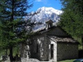
Cappella (vista laterale)
Ristorante

Scorcio
Scorcio

Fontana

.jpg)
.jpg)

.jpg)

.jpg)
.jpg)

Planpincieux

Località Planpincieux

Scorcio

Cappella

Cappella

Cappella (vista posteriore)
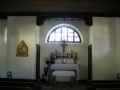
Cappella (interno)

Cappella (coro)

Pilone votivo
Centro del fondo

Meridiana

Residence

Villetta

Scorcio

Area giochi e solarium

Baita a Montite

Baita a Montite

Baita a Montite

Dettaglio cappella

.jpg)


.jpg)
.jpg)
.jpg)


.jpg)
.jpg)

Meyen

Località Meyen

Ponti sul torrente Meyen


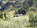
Lavachey

Scorcio

Ristoranti

Laghetto pesca della trota

Laghetto pesca della trota

Fiume Dora di Ferret (tratto)

Fiume Dora di Ferret (tratto).jpg|Fiume Dora di Ferret (tratto)

Fiume Dora di Ferret (tratto)

Scorcio

Chalet Mont Dolent

Hotel

Baite di Frebouze

Scorcio dal Rifugio Elena

Scorcio dal Rifugio Elena
.jpg)

.jpg)
.jpg)
_(2).jpg)
_(3).jpg)
.jpg)


Prà Sec

Rio Prà Sec

Ristorante

Ristorante La Grantze

Fiume Dora di Ferret (tratto)

Fiume Dora di Ferret (tratto)
Fiume Dora di Ferret (tratto)


_(3).jpg)
_(4).jpg)
_(4).jpg)
Pra Neyron

Dora di Ferret (tratto)

Ponte sul Torrente Marguera
.jpg)

Rochefort

Località Rochefort q.1.726

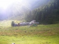
Varie

"Savoiarde" al pascolo (quota 2000 metri)
Ponte sul rio "des Econduits"

Alpeggio a quota 2.000 metri

Alpeggio a quota 2.000 metri
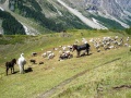
I tre somari "guardiani" del pascolo

Ruscello

Trekking

Trekking

Ponte in legno sulla Dora di Ferret
.jpg)

.jpg)


.jpg)

Video
- Alta Val Ferret
- "Elitrasporto" di materiali sul Monte La Saxe (q.2.000)


